The length of a flat single-axis solar panel can exceed 100 meters, and even minor topographical variations can cause height differences of several meters between adjacent panels in the north and south directions, significantly affecting power generation.
To adjust the height difference between adjacent supports in the north and south to an acceptable range (which may require a difference of 0.3 meters or less to reduce obstruction and facilitate the operation of cleaning robots), two approaches can be taken:
(1) Adjust the bracket using the adjustment range of the column itself. However, the adjustment range of the column is limited, generally only 0.3 meters.
(2) Level the site appropriately.
Among them, site leveling can be approached from two perspectives:
① Taking into account the natural terrain, the site is leveled into a single slope with a consistent gradient and aspect. In layman's terms, it means the site is leveled into a slightly inclined plane that closely resembles the natural terrain. The advantage of this approach is its simplicity and effectiveness. Not only does it meet the elevation requirements across the entire site in the north-south direction, but it also satisfies the requirements in the east-west direction. The disadvantage lies in the large amount of earthwork and the extensive scope of excavation.
② Taking into account the adjustment capability of the columns and the elevation differences between the north and south, as well as the east and west of the array, site leveling is only performed on the unsatisfactory areas. The advantage of this approach is that it requires less earthwork and has a smaller excavation area; however, it may result in localized water accumulation, and in some cases, it may not be able to accommodate the elevation differences between the east and west, necessitating manual intervention for adjustment.
Candela3D software adopts the second approach. Its main functions are as follows:
a. Automatically adjust the pillar, complete site leveling, and precisely calculate the amount of site leveling;
b.The results after multi-angle verification of site leveling;
c.Manual intervention of site leveling results.
Detailed functional specifications are outlined below:
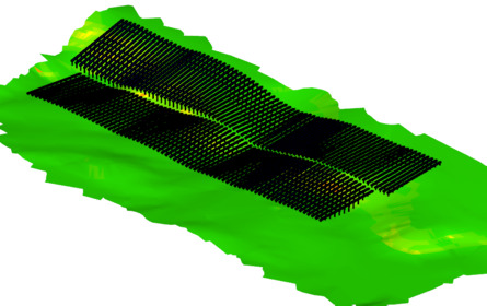
1. Automatically adjust the pillar and complete site leveling, accurately calculating the amount of site leveling
2. The results after multi-angle verification of site leveling
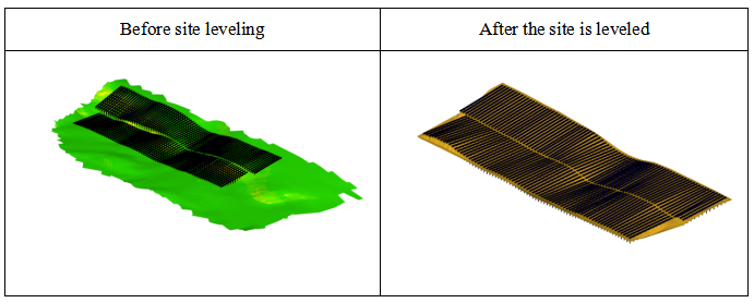
(1) Topography after site leveling and support after adjustment
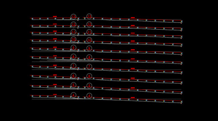
(2) Generate a cross-sectional diagram for verification
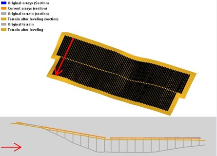
(3) Topographic profile after site leveling
3. Manually intervene in the site leveling results
(1) First manually adjust the original terrain, and then proceed with further adjustments.
(2) Based on the terrain after the last leveling, manually adjust the terrain and then proceed with further adjustments.
Article Comments(0)